Huracán Erick se fortalece y amenaza con inundaciones mortales en el sur de México
A rapidly intensifying tropical cyclone, named Erick, is currently barreling towards the southern coast of Mexico, posing a significant threat of catastrophic flooding and landslides. The National Hurricane Center (NHC) has issued urgent warnings, indicating that Erick is expected to strengthen into a major hurricane, potentially reaching category status, as it approaches the coastline.
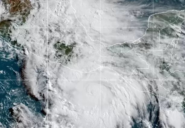
As of early Wednesday, the storm was located approximately 135 kilometers south of Puerto Angel, Mexico, packing maximum sustained winds of 175 kilometers per hour (110 mph) with even stronger gusts. Forecasters anticipate rapid intensification throughout the day, raising concerns that Erick will become a major hurricane before making its closest approach to the southern Mexican coast. The storm's center is projected to move near or over land by Wednesday evening or Thursday morning.
The NHC forecasts torrential rainfall across the states of Oaxaca and Guerrero, with accumulations ranging from 20 to 40 centimeters (8 to 16 inches), and isolated maximum amounts reaching up to 50 centimeters (20 inches). This extreme rainfall is expected to trigger life-threatening flash floods and mudslides, particularly in mountainous terrain. Additional rainfall amounts of 7 to 20 centimeters (3 to 8 inches) are expected in Chiapas, Michoacan, Colima, and Jalisco.
Coastal regions along the southern Mexican Pacific coast are bracing for dangerous surf conditions as Erick generates significant swells. These waves are expected to produce hazardous rip currents and potentially life-threatening conditions for swimmers and boaters.
Hurricane warnings are in effect from Acapulco to Puerto Angel, while hurricane watches extend westward to Tecpan de Galeana and eastward to Bahia de Huatulco. Tropical storm warnings are also in effect eastward from Puerto Angel to Salina Cruz. Residents within these zones are urged to heed warnings and take immediate precautions.
The NHC emphasizes that the projected path represents the most likely trajectory of the storm's center, but the actual impacts can extend far beyond the depicted area. There remains a significant degree of uncertainty in the forecast, with the storm's center potentially deviating from the predicted path up to 33% of the time.
Understanding hurricane forecasting tools, such as "spaghetti models," can provide insight into potential storm tracks. However, the NHC relies on a selection of the most reliable models to generate its official forecasts.
Hurricanes are born over warm tropical waters, typically exceeding 27°C (80°F). When these conditions exist, thunderstorms can organize and form a tropical wave or depression. If sustained winds reach 63 km/h (39 mph), the system becomes a tropical storm, and when winds reach 119 km/h (74 mph), it is classified as a hurricane.
Preparation is crucial in mitigating the risks associated with hurricanes. Individuals in vulnerable areas are urged to develop an evacuation plan, assemble emergency supplies, review insurance coverage, establish a family communication plan, and reinforce their homes by trimming trees, installing storm shutters, and sealing cracks. Delaying these preparations can prove fatal, especially with rapidly intensifying storms such as Erick. The National Oceanic and Atmospheric Administration (NOAA) strongly recommends immediate action to ensure safety and minimize potential losses.